Coyote Ridge Natural Area
Priority Area:
Fort Collins / Loveland Corridor Map
Size:
839.3 Acres
Description
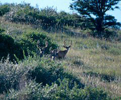
Coyote Ridge Natural Area is open to the public and is an example of a transition zone between grasslands and montane forests sometimes called montane shrublands. This property is located between Loveland and Fort Collins approximately 1 mile south of the Larimer County Landfill on the west side of County Road 19 (Taft Hill Road from Fort Collins - Wilson Street from Loveland).
Management Summary
| Yes | No | Comments | |
|---|---|---|---|
| Permit Required | |||
|
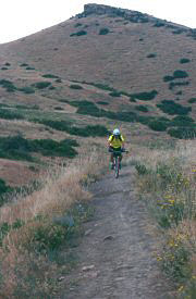
Trails Trail Map |
Easy to moderate. The trail is 3 miles roundtrip and is unpaved. It starts flat and climbs several foothills/hogbacks, eventually joining with the 4 mile roundtrip trail on the Rimrock Open Space of Larimer County Parks & Open Lands for a total of 7 miles roundtrip. | ||
|
|||
|
|||
|
|||
| Restrooms | Located one mile from the trailhead at the Cabin. | ||
| Drinking fountains | Located one mile from the trailhead at the Cabin. | ||
| Dogs allowed |
Property Information
| Type of Acquisition | #Acres |
Property Value |
Partnerships Bargain Sales Donations |
Date Acquired |
Public Access |
|---|---|---|---|---|---|
| Fee Simple | 84.3 | $ 278,500 |
Larimer Co. - $ 92,833 Fort Collins - $ 185,666 |
1997 | Yes |
| Fee Simple | 315 | $ 693,000 |
Larimer Co. - $ 346,500 Fort Collins - $ 346,500 |
1995 | Yes |
| Fee Simple | 440 | $ 924,000 |
Larimer Co. - $ 100,000 Fort Collins - $ 824,000 |
1994 | Yes |
Management Plan
Coyote Ridge Natural Area is managed by the City of Fort Collins.


